

Logistics ahead of the start
1) Where can I find and chat with other participants?
Please join the Cape Wrath Ultra participants’ Facebook Group
2) Where can I find accommodation in Fort William before the day 1 start?
Participants will need to book their own accommodation on the night before the race start. This is not included in the price of the event. We recommend using AirBnB, Booking.com or Visit Scotland to aid your search.
3) Will there be a facility to park my car provided in Fort William for the duration of the event?
Yes, participants can park their car for free at the Fort William Football Club (the registration venue) for the duration of the event. Cars can be collected from the Fort William Football Club between 9am and 6pm. This car park is not locked and cars are left at owners risk.
4) Where can I leave my luggage in Fort William?
There is an option for participants to leave luggage at the Ellis Brigham store in Fort William for the duration of the event. This can be dropped off / collected post- event during store opening hours 9am - 6pm. There is no charge for this service.
5) My return flight is from Inverness - will you transport a small bag for me to access in Keoldale?
A limited baggage transfer service (max. weight 23kg and max. size 56x40x23cm) from Fort William to Keoldale will be available strictly to those travelling to the event via public transport (geared at those needing to go straight on to an airport or train station after the event), charged at £35 to cover extra van hire and drivers. This is an optional extra and we will let you know when it is available to book pre-event.
6) What happens if I have an entry but can no longer attend the event?
Please read this article - Guidance on your options if you can no longer attend.
Have you seen our new Pregnancy Deferral policy?

An authentic Scottish welcome on the start line! ©No Limits Photography
Training
1) What is the best way to train for the Cape Wrath Ultra®?
We do not provide detailed training information for participants but would make the following two suggestions:
Practice back to back days of running in rough terrain, and using the full combination of equipment that you intend to use for the event.
Participate in an equivalent rough terrain event or adventure. The SILVA Great Lakeland 3Day™ (also organised by Ourea Events) takes place annually on the early May bank holiday. As a 3 day mountain running event, it provides the perfect rehearsal for the Cape Wrath Ultra© later in the month.
Sign up to professional coaching. We recommend expert duo Paul and Sarah at Missing Link coaching who have extensive long-distance and multi-day race training experience, but of course there are many options out there. 1:1 coaching takes into account your individual circumstances and current level of fitness.
For more tips on training, check out the participant blog section and our guidance article on training.
2) I'm not sure I'm ready for this race yet. I would like to enter next time round - is it an annual event?
Yes! The Cape Wrath Ultra® is currently held annually.
You also have the option to start in or swap to the Cape Wrath Explorer if you’re not sure if you’re ready for the full event.
After a shorter adventure? Try our new 100-mile edition for 2025, the Cape Wrath 100. Perfect to get some experience with the multi-day format before embarking on the full journey.
Our sister event, the Dragon's Back Race®, is also held annually.

Training could mean running on rough terrain or doing back to back days in the hills ©No Limits Photography
Navigation
1) How difficult will it be to navigate the Cape Wrath Ultra® route?
The route is not waymarked on the ground, and so you will be required to navigate using a GPS device and/or map. This event has been designed so that it is possible to complete it by following the GPS track. However, even if you are navigating using a GPS device, it is mandatory to carry at all times the Harvey Maps 1:40 000 scale event map that we will supply at registration. Many participants find that using a combination of both the event map and a GPS device works well for them.
It will be more difficult to follow the route in poor weather or low visibility, especially on the sections of indistinct ground. We may ‘tape’ certain tricky sections (always close to the overnight camps). You will likely find yourself travelling along with others which will help, but should not be relied upon. Overall, we would suggest map reading skills practise should be included in your training for the event.
Also of interest: our guidance on following the route article.
2) Will i be able to use the event map to follow the route?
Yes - if you are a practised map user. The event map has been optimised for this terrain and the Cape Wrath Ultra® route. If you are navigating with a GPS device then the paper map is an item of mandatory kit and must still be carried. The paper map has supplementary information such as what to do in an emergency, how to cross rivers and information about the flora and fauna in the area.
3) Is the Cape Wrath Ultra® route sign-posted?
Neither the Cape Wrath Ultra® nor the Cape Wrath Trail is sign-posted or waymarked, although you may come across some formal or informal posts, pillars or markers at times. You should not plan to rely on sign-posts to help you, and remember that the Cape Wrath Trail is a large matrix of trails from which we have derived our event route.
4) Can I complete the course with no navigational knowledge or GPS device? Can I simply follow a running buddy?
In truth yes, but we require every individual to be self-sufficient as stated in the participant declaration* which all participants must agree to when entering the event. We ask for self-sufficiency because if an inexperienced person became separated and lost, and in bad weather, then that person is much more vulnerable to an escalation of hazards and their personal safety.
Some people enter the event with friends or relatives, but you should not assume that you will be able to complete all days of the event together (in our experience it is very unlikely that you will be so equally matched over such a long event).
We also expect you to make some great friends at this event who you will undoubtedly spend some time on the route with, but please respect those who may wish to enjoy a more independent challenge.
*The participant declaration includes the statement ‘I am an experienced off-road runner’ which implies that you will have a certain capacity to resolve navigational challenges and you have declared that you are experienced enough to have a reasonable chance of completing this event - with consideration to its unique nature.
5) Would an Altimeter be useful?
Yes - altimeters can provide useful and accurate information, especially as some GPS devices will occasionally struggle to provide accurate height data in steep-sided glens. Many modern watches and devices have altimeter functions, but be aware that altitudes derived from barometric pressure are likely to be more accurate than those from GPS.
Make sure you are familiar with the operation of your altimeter before the event as you may need to calibrate it accurately.
6) Why is there a discrepancy in distance between the gpx files/Viewranger and advertised summary distances?
It is important to note that the digital route data (via ViewRanger or released GPX files) provided shows less distance and varying height gains to the information on The Route page.
There are many reasons for this, some technical, but principally because it is not possible to draw every micro-wiggle that a participant will take when actually following a track on the ground. The terrain is often rough and in steep-sided glens with many micro twists and turns, bumps and dips. GPS repeatedly, though only momentarily, struggles in these terrain types. This generally has the effect of flattening and shortening the terrain. Conversely, with online measurement, the package height data can cause an over-estimation of ascent.
The bottom line: the summary information not provided by digital route data is the better estimate of the actual distance and height gain that participants will do.
External article: How accurate is your GPS watch?
How accurate are the distances and height gains?
Finally, it is worth noting that these distances and height gains are based on the optimal route choice learnt from significant experience on the ground and considerable time spent planning and testing various route options; it is easy to run further, and many participants do.

Remember the event map supplied at registration is mandatory kit! ©No Limits Photography
GPS Navigation
1) Is a GPS device essential?
A GPS device to navigate with is not essential or mandatory, but it is recommended to aid your navigation whether this is a handheld (dedicated GPS unit or smartphone) or wrist-worn device.
2) Will you provide digital maps for my GPS device?
No. The paper event map you will receive at registration is produced by Harvey Maps and uses their 1:40,000 mapping, so we recommend sourcing digital maps by Harvey Maps. Ordnance Survey maps are also commonly available, and it might be useful to have a variety of map options.
3) Will you provide GPX files of the route?
Yes - Eight GPX files of the provisional route are already available on The Route pages (one for each day of the event). These files will be updated before each event and the final version sent to participants a few weeks prior to the event.
4) Can you help me with how to use the GPX files or my GPS device?
Sorry, we can’t offer one-to-one technical support. Any problems are often answered quickly in the participants’ Facebook Group. It is important that if you intend to rely on a GPS device, that you are familiar with accessing GPX files on it and then using them to navigate effectively.
5) Er, what is a GPX file?

Many participants find that using both a GPS device and the map works well for them ©No Limits Photography
GPS Tracker
1) Is the GPS tracker I will be issued with at registration intended to help me navigate?
No, this device is primarily for both race control and online viewers to see your location and follow your progress throughout the event. It does not have an interface that you can use to navigate with, but it does allow you to summon help in an emergency and receive messages from race control.
Race control will also be able to use it to prove your route choices should there be any need for scrutiny.
2) Do I keep the GPS tracker all week?
No, whilst you must carry it on the course each day, we will take it back off you each time you arrive at an overnight camp and reissue it to you in the morning just before you cross the day’s start line.
3) How do I carry the GPS tracker?
The GPS tracker’s antenna must always be pointed skyward, never earthward.
It must be carried at the very top of your rucksack.
It should be stored inside your rucksack, not outside.
It must never be wrapped inside anything metallic, i.e. ‘foil’ survival bags or a metal lunch box.
If taking shelter in a bothy or building, you must leave the GPS tracker outside with a clear view of the sky.

Your GPS Tracker allows race control and friends/family to follow your progress ©No Limits Photography
Equipment
1) What sort of footwear would you recommend?
Road trainers are not acceptable. We don't recommend waterproof shoes (as these will tend to hold water) - it is better to have shoes that can release water more easily through their upper fabrics. We recommend considering carefully your sock choices, including perhaps breathable waterproof socks.
You have a broad choice of footwear types; anything from deeply studded mountain shoes to general trail shoes. Grip will be essential on slippery varied terrain (such as Grass, Peat, Mud, Rock, Gravel, Sand, River Crossings) and steep descents, and the sole rubber selection can affect grip on wet rocky paths or bedrock. You should have tested your shoes before the event in similar terrain, but they should not be overly used as they will hopefully have to last 400km!
The shoes should be correctly fitted. You will be able to take spare shoes in your dry bag. It is possible that you might ‘destroy’ a pair of shoes (or the tread might get worn down) during the course of the event, and that a second pair (same or similar model), might be advisable.
2) Am I allowed to use walking poles / Should I be using walking poles?
Yes - Whether you should be using walking poles is a more difficult question to answer and depends largely on your experience and ability. There will be some ascents and descents of such gradient that poles will be a relevant choice.
The poles should be collapsible such that they fit in your dry bag should you not be using them.
3) What equipment will be mandatory to carry during each day?
Please refer to the kit requirements in the essential info section of the website. If the forecast is particularly poor, additional mandatory items may be added and this will be communicated to all participants each evening.
Conversely, we may relax on certain items if we see some assured good weather ahead. This is unlikely, but possible (the days are long and the weather is notoriously changeable), though you must come to the event with all mandatory gear to hand - any excess clothing and equipment is packed into your dry bag.
4) What if I don’t have all the mandatory equipment one day?
Having the right kit can be essential for participants' safety during the event. We have also made certain undertakings on behalf of the participants to landowners and authorities about what safety kit participants will be carrying.
Therefore, each day there will be random kit checks for ALL participants. Participants found to be missing mandatory items will receive a 'strike', participants suspected of cheating may be disqualified. If you have any questions about the acceptability of your kit please do not hesitate to contact us. See the event rules for further information.
5) Will a survival blanket suffice?
No. You must have a survival bag.
Remember - you must carry all of the mandatory equipment each day ©No Limits Photography
Overnight camps
1) Will there be the option to choose a single-sex tent?
Yes - in good time ahead of the event we will be in touch with all participants in order to ask them for their tent sharing preferences. We will always do our best to accommodate specific wishes.
2) Can I choose my tent mates?
We always try to accommodate friends and groups together in the same tent. For safety reasons, participants must stay in their specified tent during the event week. We will contact participants regarding tent allocation requests a few months before the event. The details of the final tent allocations will be available at race registration.
3) Can you find me somewhere to stay in Fort William the night before the start of the race?
Accommodation provision is from day 1 (i.e. upon arrival at the first overnight camp) through to day 4 for the 100 participants (Achnashellach) and day 8 (i.e. the last overnight camp in Keoldale) for those taking on the Ultra & Explorer. For the avoidance of doubt, participants are responsible for sourcing their own accommodation in Fort William after registration and before the day 1 start.
4) Will there be any showers?
In summary, you should not be expecting to shower after every day of running but there will some opportunity to make use of the nearest river/stream for washing in, which at least is refreshing! Here is a basic summary of what you can expect:
After day 1 = river / loch adjacent
After day 2 = stream / sea loch
After day 3 = river adjacent
After day 4 = river adjacent
After day 5 = river / sea loch
After day 6 = stream / sea loch
After day 7 = freshwater loch
After day 8 = sea loch
5) What can the Info point team help with?
The info point team, located in the main participant marquee at each of the overnight camps, is on hand to help with any issues that arise.
At the info point you can:
Collect your UltraMail, sign up for the Explorer course, buy mandatory kit, check the lost and found, get help with kit repairs, donate food if you are leaving the race, charge your devices, change your blue tent allocation (where possible), provide language translations, ask any questions, give feedback, and make emergency phone calls.
By the info point there are also TV screens displaying the weather forecast, the results and the GPS Tracking.
If you wish to leave the event, this is also where you need to go. The team can give advice on the best public transport to get you home and book taxis if needed. If you have baggage transfer, you can also collect that from here too.
MPV collection for participants on the Explorer course is also located at the info point (typically between 8-9am).

Lovely views from the campsite on day 7 ©Jimmy Hyland
Starts
1) Will I be prescribed a start time?
Day 1 - There will be wave starts between 11:00 and 12:00. Participants will be invited to select their start wave before the event.
Day 2 to Day 7 - Participants will be allocated a start window (for example between 07:00-07:30) based on their finishing time from the previous day; the slowest participants start first and fastest participants last. It is crucially important that participants start within the recommended time window or there is a significant likelihood that they will fail to meet the checkpoint cut-offs later in the day. We will likely not allow the fastest runners to start before 8:30.
Day 8 - Participants will be allocated a specific start time (for example 07:14) or a start window (for example between 07:00-07:30) which will be based on cumulative times over the first seven days of the event and will be mandatory.
We reserve the right to mandate specific start times for any/all runners each day.

Ready for a 7am start on day 6 ©No Limits Photography
Support & Services
1) Will you be providing a device recharging facility?
You can charge devices at Info Point!
2) Will you be able to recycle my spent batteries?
Yes.
3) What kind of daily support points are there?
There are no ‘support points’ or ‘aid stations’. There are some manned checkpoints where we will provide emergency help only. Please note that ALL participant dry bags are transferred directly from one overnight camp to the next, and are never accessible at any intermediate point.
4) Am I allowed outside support?
No, it is against the event rules for any participant to receive outside support, such as friends/family providing assistance or food, and contravening these rules will result in severe penalties. Please familiarise yourself with the event rules in the essential info section.
It is perfectly acceptable for friends and family to intercept participants on the course to cheer them on. Read our Guidance for supporters to find out more about cheering on points.
Supporters are welcome to wave participants off from the pier in Fort William as they take the ferry crossing over to the start at Treslaig. We ask supporters not to come to the actual start line in Treslaig.
Friends and family are welcome at the award presentation on day 8 in Keoldale (Covid-19 permitting) but must organise their own camping/accommodation for that night. Limited parking will be available close to the day 8 overnight camp but we also plan to offer a free shuttle bus service from Durness.
We ask that supporters do not enter the overnight camps on any day of the event. The only exception to this would be for the award presentation on the evening of day 8.
5) Shops, Hotels, Pubs, and Cafes etc. – Can we access them?
The route will pass through a very small number of villages and close to some shops, and if participants want to buy supplies from shops they are allowed to - but we cannot guarantee anything will be open when you pass by.
6) What availability of fresh water will there be for participants?
Drinking water will be provided at the overnight camps; this will be potable water from the mains water supply or a private supply. There will be no need to treat this water.
7) Will I need to carry sufficient water with me to drink for the duration of each day?
Not necessarily. You will be able to take water from streams and rivers as you progress along the route each day. In Scotland, river water is generally very pure although we still recommend that you treat it. You should avoid taking water from around livestock or human settlements.
Note that there will be some long sections with fewer streams, and you will need to plan appropriately.
8) What will happen if I am unable to continue and need to retire?
Please read the guidance on retirements article.
9) What medical facilities will be available?
There will be a well equipped medical team for participants at each overnight camp and a medic may be directed to manned checkpoints if required. However, in general participants will be expected to look after themselves and must bring a personal first aid kit (see kit requirements in the essential info section) for the self-treatment of most issues.
The medical team will prioritise serious incidents and ailments, but will advise on minor issues. Participants are encouraged to talk to the medical team if they have any concerns about their personal well-being.
Please read the guidance on foot care article and the medical guidance article.
10) CAN WE USE THE BOTHIES AND OTHER SHELTERS ON THE ROUTE?
Bothies are simple uninhabited shelter buildings. Yes, you can use bothies for temporary shelter or in an emergency. They are simple shelters with no beds, toilets or piped water supply.
Bothies will be marked on our Event Map, and under normal circumstances will be unlocked. If you are forced to shelter in a bothy, during the day, evening or overnight, we will NOT treat it as an emergency, but you must leave your tracker outside the building so that it remains active and we can both message you and see where you are.
Despite many bothies looking like nicely maintained and inhabited cottages, most are very remote, with access only possible by foot. Whilst bothies will provide excellent temporary shelter, they are often NOT sited in the best places to retire and expect vehicle assistance!
11) How can friends & family follow the race?
Friends and family can follow participants in real time via the live GPS Tracking page. They can also send messages of support via Ultra Mail! These are messages sent via the GPS Tracking page to individual participants. This is always a hugely popular service that can provide fantastic motivation for participants! Details on how to send Ultra Mail will be shared with active participants just before the event.
Friends & family should also follow race coverage on Facebook, Instagram and Twitter, as well as reading the daily news stories on the website.

Our team there to cheer you on at the checkpoints! ©No Limits Photography
Catering
1) What is the catering provision like?
Please read the catering section on the essential info page.
All meals at the overnight camps are based on a meat and fish FREE menu with the option of adding diary, cheese and eggs to make them vegetarian. All the meals are high in calories and nutritionally complete to provide the right balance of micro and macro nutrients for participants undertaking a very tough physical challenge.
Why a meat and fish free menu? Read our sustainability policy here.
2) Will I always be able to get a drink at the overnight camps?
Tea, coffee (with decaf options), peppermint tea, squash, and hot water will be available whenever the kitchen is open (i.e. most of the time).
3) Will there be unlimited food and will it be available at all times?
Whilst there will be plenty of food, it is important to note that any one type of food is not unlimited, and the catering tent is only open at specific times.
We serve standard portions of meals and ask that hungry participants come back to the catering tent for a second helping. This policy reduces food waste enormously and helps to ensure that everyone at the event is well fed each day.
4) Hill Food
Participants must supply sufficient quantities of their own food for eating out on the course between overnight camps each day. It is clearly important that participants do not underestimate how much food they require. The route will pass occasionally via food outlets/shops.
Note that it is strictly prohibited for participants to take food from the catering tent to supplement their hill food and this will be checked as part of random kit checks each day.
5) Condiments
A selection of condiments will be available to compliment the main meal such as ketchup and chutnies.
6) Allergens
These will be announced ahead of the event.
7) Diagnosed food allergies
For participants that have a diagnosed food allergy that is evidenced by a letter from their doctor, we are able to provide an additional baggage allowance (10kg) so that they can carry additional food and cooking equipment only.
In all cases, we are unable to transport food that requires refrigeration or freezing, and this additional food/equipment will be transported with the general overnight dry bags. Our kitchen is unable to prepare any special meals, and participants with their own food will need to prepare this in main marquee (no food preparation/cooking is allowed in the blue tents).
The realities of preparing meals for hundreds of participants in a basic kitchen in an expedition race setting means that we are unable to guarantee the separation of food allergens (for example diary, nuts, etc.) when the meals are prepared and served. We are able to provide gluten free meals.
We will of course do everything reasonably practicable to accommodate the requirements of the participants within the boundaries of the menu being offered.
Sorry, we are unable to give special dispensation for participants with personal dietary preferences that fall outside our menu.
8) Fruit
We will do our best to provide some fresh fruit for participants but issues around supply, demand and storage make this challenging.

Refuel for your next big day ©No Limits Photography
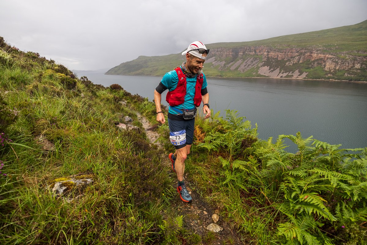
THE COURSE
1) What will the terrain be like for running on?
Please read the route section for detailed information about the nature of the route each day.
The full event route terrain type can be summarised in this pie chart showing average terrain type:
The majority of the course is on good tracks and paths, with sections of indistinct paths or pathless terrain. Sometimes even the paths can be challenging and require your full attention. There are also occasional sections of quiet tarmac road.
For a skilled, experienced and fit mountain runner the course is runnable, but for someone with limited experience of rough multi-terrain running, they should expect to have a tough challenge.
2) How difficult will the River Crossings be?
This will depend on the weather conditions. The route is planned to make the best use of bridges and safe crossings where practical. If there is persistent wet weather, this may result in some larger rivers becoming uncrossable and we would then alter the route for that day.
The numerous smaller rivers and streams will be crossable unless there is torrential rain. You are likely to get wet feet every day even in the best weather.
Read the river crossing guidance article pre-event. This info will also be summarised on the event map.
3) Will you allow reconnaissance of the route and the terrain?
No problem. Enjoy the Highlands! In fact, if you are exploring over the winter, please update us on your findings. With every winter there can be changes such as flooding, wind damage and coastal erosion. We are particularly interested in any information regarding remote bridges and path conditions. Please do take responsible access and be aware that estates operate various activities such as stalking at different times of year. Check this website for practical information about when to visit or not. We regularly have requests from estates to avoid the stalking season so this is very important for the ongoing existence of the event.
Check out this article about the official recce offerings from Trail Running Scotland.
If you plan to explore the Day 8 route, please be aware that the northernmost section is owned by the Ministry of Defence, and they have a tendency to drop bombs fairly frequently. You are welcome to cross the area, just make sure you check to see if they have any activities planned first! If you see any red flags, that means you should not enter. There is usually information available on their planned activities at the Sandwood Bay car park, and online here. Feel free to contact us for more information.
4) How long will it take to run each day?
We expect on most days that the fastest participants will be out for on average 8 hours, and the slowest participants will be out for approximately 16 hours.
Remember that day 1 and day 8 are significantly shorter days.
Please have a look at the results to gauge how long the participants were out for on past events.
5) How long do I have to complete each day?
The earliest start is from 07:00 and the course closure time each day will be 22:00.
If you arrive into camp after 22:00 then you will be classed as non-competitive in the results, but you can stay with the event by swapping to the Explorer course.
Read our guidance article on continuing non-competitively.
Exceptions to this:
On day 1 there are wave starts at 11:00 and 12:00.
On day 8 you have until 17:00 to complete the course.
See key timings in the essential info section for more details.
6) How remote is the terrain and the route?
Very - this is what you are here for!
During much of the event you will have no phone signal and may be many kilometres away from the nearest civilisation. Likewise, we will have little to no vehicle access to the route for extensive sections. Often the best means of access (other than on foot) is by boat.
The nature of the terrain means that long inland journeys are required to travel northwards by vehicle. If you are concerned about being alone out there - make some friends and travel together!
7) What is the EXPLORER course?
Upon entering the Cape Wrath Ultra®, you can choose either the Explorer course or the full race route. The Explorer course offers the opportunity to do part of the full race route each day. This option is a great stepping stone to completing the full race route in the future, but also a brilliant experience in its own right.
Also, participants who fail to complete one or more days of the full race route (i.e. arrive at a checkpoint after the cut-off time, arrive at the finish after the course closure time, or decide to withdraw from that day's course) will be allowed to continue in the event by swapping to the Explorer.
8) What is the CAPE WRATH 100?
The Cape Wrath 100 is a new 100-mile challenge for 2025 that takes in days 1 - 3 of the full Cape Wrath Ultra®.
Whether you’re Cape Wrath curious and looking to dabble in the multi-day race experience before embarking on the full journey, simply after a shorter adventure or looking to push for some harder, faster efforts over the rugged and wild terrain of the Cape Wrath trail, the new 100-mile offering certainly has something for everyone.

Expect plenty of good tracks and paths on your journey to Cape Wrath ©No Limits Photography
Weather & Environment
1) What sort of weather conditions can I expect?
May is often the best time of year to run in the mountains in Scotland, hopefully with clear sunny skies and cool breezes. Peak daytime temperatures reach 25°C (77°F).
However, it is also likely that participants will experience low cloud, rain, wind and temperatures closer to 5°C (41°F) during some days. With wind-chill and rain these are potentially very dangerous conditions.
As with all mountain environments the weather can change quickly and we expect participants to wear/carry the appropriate clothing (please see kit requirements in the essential info section) each day, some of which will be mandatory. A weather forecast will be posted at the overnight camp each evening and morning.
2) Will I get sun burnt?
A combination of the sun, the latitude and the slightly thinner atmosphere in the north make this quite possible, so precautions are essential. It is also possible to become dehydrated and, even more seriously, suffer heat injuries.
See our Medical guidance article for more info.
3) Will it be windy?
At times, yes, very likely, so good clothing equipment choices are essential.
Please read the kit requirements in the essential info section.
4) Will we be in darkness whilst running?
Probably not - it should only be dark when you are at the overnight camps, unless you are one of the last runners on one of the longer stages of the event.
Sunrise will be at approximately 04:30 and sunset at approximately 22:00 during the event, with complete darkness by approximately 23:00. You will be carrying a headlamp as this is mandatory equipment while running (please see kit requirements in the essential info section).
5) How do we prepare for midges? Are they as bad as people say?
Yes - They can be as bad as people say! Midge conditions vary each year according to the weather, but May usually avoids the worst conditions. Midges should not be a problem during the day.
A midge net is part of the mandatory camp clothing and equipment (please see kit requirements in the essential info section). Note that mosquito nets are not sufficient as midges are much smaller.
We recommend that you keep your tent doors and zips closed.
6) How nasty are Ticks? Any prevention advice?
Ticks can carry a nasty infection called Lyme Disease, and although it seems to be rare in the Highlands, it is not worth taking any risks. It is important to find and remove ticks every day.
You should bring a tick removal tool and know how to use it. Long clothing will help stop ticks attaching themselves to you. You may wish to find a friend to help you check!
See our Medical guidance article for more info.
7) Are there any dangerous or poisonous animals in the Highlands to be aware of?
There is a very, very low risk of dangerous encounters with animals. Adders (snakes) are venomous, and the consequences of a bite can be fatal if untreated rapidly. Encounters are extremely rare in the Highlands.
In very extreme circumstances deer or cows (bulls) can charge at you (especially if they feel threatened in some way). Keep your distance and there shouldn't be any problems.

You should be ready for all types of weather in the Scottish Highlands ©No Limits Photography
Mobile network coverage
1) Will There be mobile phone signal at the overnight camps?
The following mobile phone networks have been tested at the overnight camps. O2 and Three have not been tested sufficiently. Often the signal is poor and 3G/4G coverage is rare even if voice calls are possible.
Event Centre - Fort William
EE and Vodafone
Day 1: Glenfinnan
EE and Vodafone
Day 2: Kinloch Hourn
None
Day 3: Achnashellach
EE and Vodafone
Day 4: Kinlochewe
EE and Vodafone
Day 5: Inverbroom
EE
Day 6: Inchnadamph
None
Day 7: Kinlochbervie
EE and Vodafone
Day 8: Keoldale
EE and Vodafone
2) Will there be wi-fi available at the overnight camps?
Sorry, no. Race control will maintain a satellite internet connection for safety monitoring but access will be strictly limited to relevant event personnel only.

Switch-off, relax and enjoy the wilderness experience ©Ian Corless
Elite Entry Criteria
For Elite Runners, to gain a free race entry to one of the Ourea Events races, this is determined by either their overall UTMB Index or their ITRA Performance Index. You must demonstrate that you have a valid and current score in either index. Elite entries are limited per race and will be determined by their demand and availability.
UMTB Index (overall)
Men 800
Women 650
ITRA Performance Index
Men 825
Women 700
Where this quota has been reached, races are sold out, registrations are closed or less than 30 days before the event, free entries will be subject to the event director’s discretion. Please submit a request via the contact form on the race website.